Tuesday, October 27, 2015

Wakatobi National Park

Wakatobi National Park is one of 50 parks nasoinal in Indonesia, located in the district Wakatobi, Southeast Sulawesi. This national park is set in 2002, with a total area of ​​1.39 million ha, concerning marine biodiversity, scale and condition of coral; which occupies one of the highest priority position of marine conservation in Indonesia. The depth of water in the park is varied, the deepest part reaches 1,044 meters below sea level.
 

Wakatobi become one of the national park that has the beauty of the underwater world that is no less great than the Raja Ampat and Bunaken. For those of you who like diving, you should obligatory visit Wakatobi. Waktobi located in Southeast Sulawesi province.

In this park there is a panoramic view of the beauty of the underwater world that has 25 pieces of coral reef. Coral reefs can be found around 112 species of 13 families located at 25 points along the 600 km coastline.


In addition to the beauty that is presented by a wide range of coral reefs, the park also has a variety of fish species. Fish species richness of this national park which is owned as many as 93 species of fish and ornamental fish trade consumption. For tourists who love the beauty of the underwater world can do some activities in Wakatobi National Park, such as diving, snorkeling and swimming to see the beautiful coral reefs and a variety of underwater animals and also witnessed various local culture.
 

The beauty and richness of Wakatobi National Park area is already well known in foreign countries, especially after Wallacea expedition from England in 1995 which states that the area in Southeast Sulawesi is very rich in species of coral. There, there are 750 of the total 850 species of coral in the world. Configuration depth varies from flat to sloping to the sea and in some areas there are bertubir steep waters. The deepest part of the waters reaches 1,044 meters.
 

More than 112 species of coral from 13 families can be found in Wakatobi, including: Acropora formosa, A. Hyacinthus, Psammocora profundasafla, Pavona cactus, Leptoseris yabei, Fungia molucensis, Lobophyllia robusta, Merulina ampliata, Platygyra versifora, Euphyllia glabrescens, Tubastraea frondes , Stylophora pistillata, Sarcophyton throchelliophorum, and Sinularia spp who live in harmony with other underwater inhabitants.
 

Fish species richness owned this national park as many as 93 species of fish such (Cephalopholus argus), takhasang (Naso unicornis), pogo-pogo (Balistoides viridescens), napoleon (Cheilinus undulatus), perch (Lutjanus biguttatus), rabbitfish (Siganus guttatus) , Amphiprion melanopus, Chaetodon specullum, Chelmon rostratus, Heniochus acuminatus, Lutjanus monostigma, Caesio caerularea, and others.
 
Wakatobi National Park is also home to several species of sea birds such as geese-Stones Brown (Sula leucogaster plotus), Malay plover (Charadrius peronii) and Eurasian kingfisher (Alcedo atthis) nesting. Several species of sea turtles also make this park their home such as the hawksbill turtle (Eretmochelys imbricata), loggerhead (Caretta caretta) and Olive Ridley turtles (Lepidochelys olivacea).
 

Wakatobi waters have loyal guests who make Wakatobi waters as a playground, the guest was none other than the sperm whale (Physeter macrocephalus). Typically, sperm whales are in Wakatobi in November, while the other hemisphere frozen. In the relatively warmer Wakatobi waters and abundant food that can satiate the stomach whales. Not only that Wakatobi is also a playground manta ray (Manta ray) are classified as giant body size. Mantas is one type of fish that is distinctive and unique, which is only found in tropical waters.
 

Wakatobi formation began in the tertiary era until the end of the Miocene age as a result of geological processes in the form of a sliding fault that can not be separated from the operation of tectonic style. Overall this archipelago consists of 39 islands, three charred and 5 atolls. Of the process of formation, in contrast to the atoll in Wakatobi atolls located in other areas. Atoll in this area is formed by the presence of the sinking of the base plate. Some atolls are visible now, among other things Kaledupa Atoll, Kaafu kapota and Tomia Atoll.
 

Wakatobi waters are at the "Coral Tri-Angle" or the coral triangle region, ie the region which has a diversity of coral reefs and other marine highest biodiversity in the world, including the Philippines, Indonesia to Solomon Islands. The existence of 25 pieces of coral reef and makes the ideal depth waters in the Park an ideal place for many species of marine life to live, making sea dwellers here have aesthetic value and high conservation.

Specifically the Park surrounded by beaches of coral islands along the 600 km and beach destination with huge potential to be managed, scattered throughout the Wakatobi region. So it was not without reason that the beach area in Wakatobi is perfect for sightseeing as diving, snorkeling, swimming and fishing.

Lake Singkarak

Lake singkarak is a lake that stretches in two districts in West Sumatra, Indonesia, which is the district of Solok and Tanah Datar. This lake has an area of ​​107.8 km² and is the 2nd largest lake on the island of Sumatra. This lake is upstream Ombilin River. However sebahagian lake water is channeled through a tunnel cut through the Bukit Barisan to Batang Anai to drive a generator hydropower singkarak near Lubuk Alung, Padang Pariaman district.
 
Teletak singkarak lake on the island of Sumatra is one of the best tourist attraction in Indonesia. singkarak Lake is located in the province of West Sumatra, precisely in located in Tanah Datar and Solok district. singkarak Lake is the second largest lake in Sumatra after Lake Toba. Lake singkarak beauty into this place as one of the favorite tourist attraction in Indonesia, both for tourists both domestic and foreign tourists. Besides enjoying the natural beauty of Lake singkarak, tourists can enjoy a train tour to Lake singkarak background.
 

A sea of ​​clear water, fishing boats scattered on the surface of the lake for fishing, plus a green landscape around the lake. Yes, the view of this kind will be found in Lake singkarak, West Sumatra. This lake is about 70 km from Padang, capital of West Sumatra.

Because of its beauty, Lake singkarak become one datu sights crowded with people around and also from outside the city. The beauty of this resort was first known in 1905 through biology journal belonging to Ernst Haeckel, a researcher from Germany. Not only examines singkarak lake and surrounding ecosystems, Haeckel was also amazed by the beauty of this lake, making it encapsulates the beauty of Lake singkarak in a painting.


There are many activities you can do to enjoy the lake singkarak. You can swim in the clear lake water, the boat ride around the lake, fishing by the lake or join the fishermen catch fish. Do not forget to bring your camera to capture the beauty of this tourist spot. Large lake with a green background Bukit Barisan opposite a pity to miss.
  
As the lake once the pride of West Sumatra natural attractions flagship, singkarak Lake has some unique things interesting for you to know, including:

Tour de singkarak

singkarak Lake to be part of the Tour de singkarak, an international cycling event is regularly held every year. Tour de singkarak supported by the Ministry of Tourism and Creative Economy and the Amaury Sport Organisation, organizer of similar events in France, the Tour de France.
 
Tour de singkarak first held in 2009. Furthermore, when implementation takes place during the week between the months of April to June with seven stages that must be passed by the participants. Tour de singkarak not just a cycling race on the highway, but also the introduction of the culture and the natural beauty of West Sumatra. Along the route to be taken, participants will be treated to views of Minang cultural diversity and natural beauty of West Sumatra.
 
At first, the Tour de singkarak starts from the starting line in the city of Padang and ending at Pier singkarak lake. Then, since 2012, the starting line starting from Sawahlunto, a historic old town in West Sumatra and ends in the city of Padang. Although no longer the site of the finish line, but the lake singkarak still remain part of the Tour de singkarak along with Lake Maninjau and several other interesting sights.

Cave Tubing Kalisuci

Goa Kalisuci Located in the village of Pacarejo Semanu, with a distance of 12 km from Wonosari. Kalisuci located in Padukuhan Jetis Wetan Village Pacarejo, Semanu, Gunung Kidul regency, Yogyakarta. GPS coordinates S8 ° 0'34.76 "E110 ° 38'21.36" (see map). Is a special interest tours that offer fringe of the river (rafting) underground at once fringe cave (cave tubing) in the karst area of ​​Gunung.


Uniqueness is encountered the phenomenon of formation of landforms, karst surface be formed depression collapse that form caves vertical and formation of positive form of hill karst cone-shaped, while below the surface in the form of underground river that flows through the caves horizontal is a system underground streams which are interconnected to each other in karst area of ​​Gunung. In this area, tourists can do cave fringe activity by using special equipment such as boats, ropes, and others. Tourists can also enjoy the beauty of Kalisuci cave with stalactites and stalagmites, beauty and coolness are fused and challenging adventure.
Passing through the river which flows through the underground caves become one of the tourism potential of this place has to offer. With a guide, you will be invited to drift into the cave Kalisuci and Luweng Glatik (cave Glatik). Not to be able to swim, all visitors will be equipped with a life vest and helmet as a means of safety standards. Goa is quite long with the ceiling is quite high and the depth of the river about 2-3 meters. Throughout the trip will also be a lot of explanations of the guide. In the cave is quite dark and did not provided information in order to maintain the existing ecosystem in the cave.

Underground river that flows beneath limestone mountain range that empties into the sea south of the island Jawa.Merupakan one of three cave tubing adventure tourism centers in the world, after Mexico and New Zealand.

Kalisuci a karst cave tour with an underground river that is currently used as a new tourist attraction in Gunung Kidul. Kalisuci located about 10 kilometers from Wonosari is precisely Pacarejo village, Semanu, Gunung.
 
Cave Tubing is located in the tourist village of Pacarejo, Semanu, Gunung Kidul about 60 kilometers from the city of Yogyakarta, takes about 1.5 - 2 hours drive.

We recommend that you use a private vehicle to get to the location of Cave Tubing Kalisuci. Given the road conditions such as the rise and fall will require excellent stamina vehicle. Before getting to the location basecamp, participants must pass through rocky terrain about 500 meters, and can only be reached on foot.
Cave Tubing up to the location, you will see an underground river with water flowing through the cave - Grubug karst caves such as the Cave and Cave Jomblang frequently used groups of nature lovers to search the cave.

For those who like adventure with nature, Cave Tubing Kalisuci Wonosari Yogyakarta could be the choice of our vacation in the city of Yogyakarta. Cave Tubing Kalisuci itself is located in Jetis, Pacarejo, Semanu, Gunung Kidul. This location is 50 km from the city of Yogyakarta and about 10 km from Wonosari.

Cave Tubing itself is a mix between rafting (rafting) with caving (caving), Cave Kalisuci have water flow swift and rivers located in the cave, then cocoklah when the activity of the wild-free has become a challenge stunning for adventure lovers of nature.

Derawan Island

Derawan Islands is an archipelago located in Berau, East Kalimantan. In this archipelago there are a number of charming nautical tourism, one of which Parks Underwater interest foreign tourists, especially divers world-class.

Derawan Islands has three districts namely, Derawan, Maratua, the Big Dipper and the Big Dipper, Berau. At least four of the famous islands in the archipelago, the island Maratua, Derawan, Charitable and Kakaban inhabited by endangered green and hawksbill turtles.

Geographically, it is located in the northern peninsula of marine waters Berau district consisting of several islands of Long Island Raburabu, Island Samama, Charitable Island, Kakaban, Island Nabuko, Maratua Island and Derawan Island and some reefs such as burnt Muaras, charred Pinaka , charred Buliulin, Masimbung scorched and charred Tababinga.
 
Derawan Islands coastal ecosystem and there are several small islands very important that coral reefs, seagrass beds and mangrove forests (mangroves). In addition, many protected species are in Derawan Islands such as the green turtle, hawksbill turtles, whales, dolphins, clams, coconut crabs, mermaids, fish, barracuda and a few other species.

Derawan Islands is being promoted by Berau and East Kalimantan Province, as one of the mainstay tourism. Foreign and local tourists, the more traveled there, no choice but to dive, see the nesting turtles, also enjoyed the beach clean and beautiful. Along the beach is clean and no rubbish. Communication facilities in Derawan Islands has been good, as for example, is already covered with 3G signal.
 

Resort and Lodging in Derawan Islands are scattered on the beach, with for example a cheaper price compared to tourist spots in Bali and Lombok. Derawan Islands has been nominated to become a UNESCO World Heritage Site in 2005.

One of the beautiful tourist attraction in the area is along the coast of East Kalimantan on the island Derawan. In recent years this place stuck out as one of the excellent vacation to an exotic beach in Indonesia. Objects of interest both from the marine park with beautiful coral, soft white sand and of course the natural cruising enchanting island archipelago that makes it very attractive. The beauty of what can be explored? How to get to this object? And where is it located? Here is a review of interest that can be used as guidelines for those of you who want to vacation in East Kalimantan Derawan region.

Paths commonly used by tourists from outside Borneo is by plane via Sepinggan, and connected with a small plane to the airport Kalimarau in Berau. Currently under development phase Berau airport in order to be able to call on wide-body aircraft. And other alternative is via Tarakan connected by speed boat. The latter alternative would require a fairly high cost and time your trip to the island Derawan be longer. Arriving at the airport, your journey was continued by car (taxi) to Tanjung Batu to cross over to the exotic islands by speedboat. In addition to around Berau, on these islands are also widely available resorts and hotels. The best advice, lodged more than 2 days in this area so that your holiday trip becomes a complete visit coastal tourism in this Berau.
 

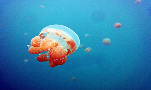
The beauty of the beach Derawan that you can enjoy include diving and snorkeling. Reviewing breeding Hawksbill and Green, jellyfish benign and other biota including the beautiful coral reefs is the main thing that you can enjoy. Special jellyfish are often benign aired by the television media is on a lake Kakaban. There are four islands are quite popular, namely Derawan, Maratua, Kakaban and Charitable. Fourth into the Berau district (this is where your basecamp usually stay). We suggest you take a complete tour packages provided by many travel agents. Because if you want private, then the costs to be swollen, especially around the cost archipelagic beautiful with a motor boat.

In the surrounding waters are a marine park and famous as a tourist diving (diving) with a depth of about five meters. On a rock at a depth of ten meters, there is a rock known as "Trigger Blue Wall"

Cukang Taneuh Green Canyon, (Indonesia)

Cukang Taneuh or Green Canyon (Green Canyon) is one of the attractions in West Java which is located in the Village District Cijulang Kertayasa, Ciamis District ± 31 km from Pangandaran.


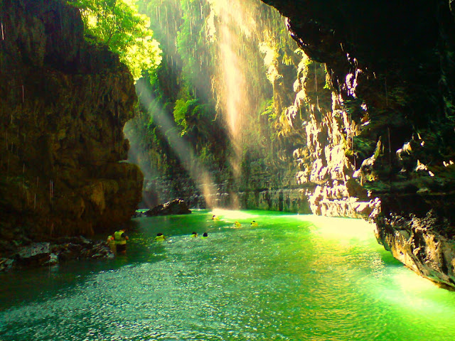
This canyon is formed from soil erosion due to the flow of the river Cijulang over millions of years through the cave with stalactites and stalagmites fascinate and flanked by two hills with rocks and trees presents unique natural attractions and challenging. To reach this place, we had to hire a paddle boat on the dock Ciseureuh. His journey takes approximately 30-45 minutes with a distance of about 3 km to get to the Green Canyon.

Throughout the journey, our eyes will be spoiled by teduhnya green color of the river water. At the mouth of the cave there is a waterfall Palatar so that the atmosphere in this attraction was so cool. Activities that can be done include rock climbing, swimming, boating while fishing. To reach this location, tourists can use boats that are widely available at Pier Ciseureuh, both outboard boats and paddle boats. Degan this attraction adjacent attractions Batukaras and Nusawiru Airport.


Green Canyon save a tremendous charm. A blend of rivers, green valleys, protected forests, and various stalactite-stalagmite. Beauty wrapped in silence, like a hidden paradise. Green Canyon began to be developed in 1989.

Green Canyon name coined by the French in 1993. However, the Sundanese call Green Canyon as Cukang Taneuh or in Indonesian means Land Bridge. Green Canyon's name is also a pun on the name of the Grand Canyon in Colorado, USA.


With the beauty offered by the Green Canyon, you'll be amazed. So do not forget to set up the camera during a trip down the river. Aim beautiful objects to be missed. Do not forget to prepare wrapper waterproof camera because here later you will interact with water.

During a long way in ketinting, later you will meet a variety of flow stream that allows for you to swim. You can swim in the river water is super clear, looking at the fish swimming.
You can stroll through the cave with stalactites and stalagmites dripping. During a trip on a boat, you can also enjoy the roar of water falling on the cliffs.


If you like a challenge that stimulate adrenaline, you can try to jump into the river from a rock altitude of 5 meters or try rock climbing attraction. Meanwhile, for those who like quietness, boating while fishing will be a delightful choice.

Tips traveled in Green Canyon
The beauty of Green Canyon flanked by high cliffs
  1. Do not forget to bring a change of clothes, because here you will be a lot of interaction with water. 
  2. Do not forget to bring a special waterproof bag to protect your electronic items such as mobile phones and cameras. 
  3. Use anti-slip footwear, because you will often walking on slippery rocks. Try to wear sandals to be more comfortable mountain. 
  4. Bring some food and drinks themselves because there is only food vendor at the main entrance. 
  5. Most importantly Do not litter! Bring plastic bags to dispose of waste so that the beauty of the Green Canyon tourist spot is maintained. Unfortunately not if Green Canyon's famous clarity of the water is polluted our own hands?

Friday, October 23, 2015

Lake Kelimutu

Kelimutu is a crater lake situated atop Mount Flores (volcano) located on the island of Flores, NTT Province, Indonesia. The mountain location is precisely in the Village Pemo, District Flores, Ende.


The lake is known as the Lake Three Colors because it has three different colors, namely red, blue, and white. However, the colors are always changing with the passage of time.


Lake or Tiwu Kelimutu divided into three sections corresponding to color - the color that is in the lake. Blue lake or "Tiwu Nuwa Muri Koo Fai" is a gathering place for the souls of young people who have died.

Lake of the red or "Tiwu Ata Polo" is a gathering place for the souls of the dead and as long as he lived always do evil / witchcraft. While the lake is white or "Tiwu Mbupu Ata" is a gathering place for the souls of parents who have died.


Kelimutu Is a combination word of "keli" meaning mountain and the word "quality" which means to boil. According to local belief, the colors on the lake Flores has the meaning of each and have a very powerful force of nature.

The residents around Lake Kelimutu believe, that when the lake changed color, they have to give offerings to the spirits of people - those who have died.


The third broad lake was approximately 1,051,000 square meters with a volume of 1292 million cubic meters. The boundary between the lake is narrow stone walls prone to landslides. The wall is very steep with 70-degree angle. Lake wall height ranges from 50 to 150 meters.

Lake Toba

Lake Toba is a volcanic lake with a length of 100 kilometers and 30 kilometers wide, located in the province of North Sumatra, Indonesia. This lake is the largest lake in Indonesia and Southeast Asia. In the middle of this lake there is a volcanic island called Samosir Island.


Lake Toba is an amazing natural wonders on the island of Sumatra. Hard to imagine there is a more beautiful place to visit in North Sumatra in addition to this lake. Refreshing cool atmosphere, blue expanse of clear water and stunning views of the green mountains are a small part of a giant image of the lake is 900 meters above sea level.

Lake Toba is a lake cratered area of 1,145 square kilometers. Dwell in the middle of an island with an area that is almost proportional to the area of Singapore. Lake Toba is actually more like a sea than a lake considering its size. Therefore, the Lake Toba placed as the largest lake in Southeast Asia and the second largest in the world after Lake Victoria in Africa. Lake Toba also includes the deepest lake in the world is approximately 450 meters.

Lake Toba is expected to experts formed after a volcanic eruption super approximately 73000-75000 years ago. At that time 2,800 cubic km of volcanic material spewed out of Mount Toba erupted to the volcanic dust in the wind spread to half of Earth. The explosion occurred during 1 week and throw the dust up to 10 kilometers above sea level.

Lake Toba is a volcanic lake with a length of 100 kilometers and 30 kilometers wide (the largest volcanic lake in the world). In the middle of this lake there is a volcanic island called Samosir Island. Lake Toba has long been an important tourist destination in North Sumatra, Bukit Lawang and Nias, attract domestic and foreign tourists.

Lake Sentani

Lake Sentani is a lake located in Papua, Indonesia. Lake Sentani is under slopes of the Cyclops Mountains Nature Reserve has an area of approximately 245,000 hectares. This lake lies between the city of Jayapura and Jayapura regency, Papua. Lake Sentani which has an area of approximately 9,360 hectares and is located at an altitude of 75 meters above sea level. Lake Sentani is the largest lake in Papua.


In this lake also there are 21 small islands adorn this beautiful lake. Sentani sense of the word means "here we live in peace." Sentani name itself was first mentioned by a Christian Pastor BL Bin when carrying out missionary in the lake region in 1898.


This lake has been managed as a tourist attraction due within 50 kilometers of Jayapura and easy to reach, as a complement to the lake there are many tourist boat to get around Lake Sentani.


In this lake there are 30 species of freshwater fish and four of which are endemic to Lake Sentani namely catfish Lake Sentani (Oxyeleotris heterodon), rainbow fish Sentani (Chilatherina sentaniensis), rainbow fish red (Glossolepis incisus) and shark saws (Pristis Microdon). Lake Sentani rich variety of marine life and has been used for freshwater fish farming.

Lake Sentani is also used as a tourist location for swimming, boating, diving, fishing, water skiing and culinary tourism. Antaraketiga endemic fish in the lake sentani whose population is dwindling fish cork Lake Sentani, this is because the eggs of these fish eaten by fish cork from other species.


You can fish, swim or drive around a lake with boat rental. If you still feel are lacking, why not visit the local villages? You can stop by the homes and talk while enjoying the culinary trademark.


This lake is also held in the Lake Sentani Festival to attract tourists. Lake Sentani Festival is usually held in mid-June each year, FDS itself has been established as an annual festival and entered in the main tourism calendar. The festival is filled with traditional dances on boats, Papua typical war dance, traditional ceremonies such as the coronation Ondoafi, and serving a variety of unique culinary Papua.

If you visit in mid-June, congratulations! You might as well enjoy the Lake Sentani Festival. The festival is an annual event featuring a variety of art and cultural performances Papua. In addition, a variety of unique culinary Papua you can enjoy here.

Baluran National Park

Baluran National Park is a national park in Indonesia, located in the territory Banyuputih, and Wongsorejo Situbondo, Banyuwangi (north), East Java, Indonesia. The name of the national park is named after the mountain located in this area, namely Mount Baluran. Gate to enter the Baluran National Park is located at 7 ° 55'17.76 "S and 114 ° 23'15.27" E. This national park consists of savannah vegetation types, mangrove forest, monsoon forest, coastal forest, lower montane forest, swamp forest and evergreen forests throughout the year. Savannah vegetation types dominate Baluran National Park which is about 40 percent of the total land area.


Baluran National Park is the largest savanna in Java with animal and plant species are diverse. A visit to this location makes you seoalah are in Africa. That is why the National Park is often referred to as his African Indonesia.


Here you'll be treated to a view of a herd of deer running towards the pool of water to drink, the peacock spread its tail, hordes of buffaloes and elephants, dozens of eagles that fly to foraging until the monkey hanging in a tree. The scenery is exactly as you can find in Africa.


In addition to the hordes of animals that are free to move in the wild you will also be treated to a view of 444 native plant species typical as Widoro bukol (Ziziphus rotundifolia), and neem (Azadirachta indica). The third plant is a plant species that is able to adapt to very dry conditions. When other plants have started to dry, the third species is still green.


In addition to 444 species of plants, here too there are 26 species of mammals and 155 species of birds. Mammals that live in Baluran National Park is like bison, deer, leopards, deer, cats and mangroves. There are also some rare birds such as kites fire, tuwuk / Asian Koel, red jungle fowl, hornbill, hornbills, and the stork casks.

Baluran National Park is representative of the dry forest ecosystem in Java with the type of savanna vegetation, mangrove forest, monsoon forest, coastal forest, lower montane forest, swamp forest, and forest green. 40 percent of savannah vegetation dominates the park.


The road leading to the Baluran National Park is very convenient because it was paved and a traffic lane that connects the province of Bali, Banyuwani to Surabaya so that those who are in the nearby towns can access easily.


The road leading to the Baluran National Park is very convenient because it was paved and a traffic lane that connects the province of Bali, Banyuwani to Surabaya so that those who are in the nearby towns can access easily.